Things come up. Odd stuff in the news. Whims and such. Sometimes we even do something. I keep this blog so that folks who might be interested can keep in touch in what we (that's Di and me) are up to and find interesting from time to time.
So, I maintained a bit of a diary on the iPhone while we were on our hike. The idea was to make just a few notes for each day and add a few photos to show the richness of the route. I hope you'll like it. Later I'll make a larger gallery on my SmugMug site when I've got more time.
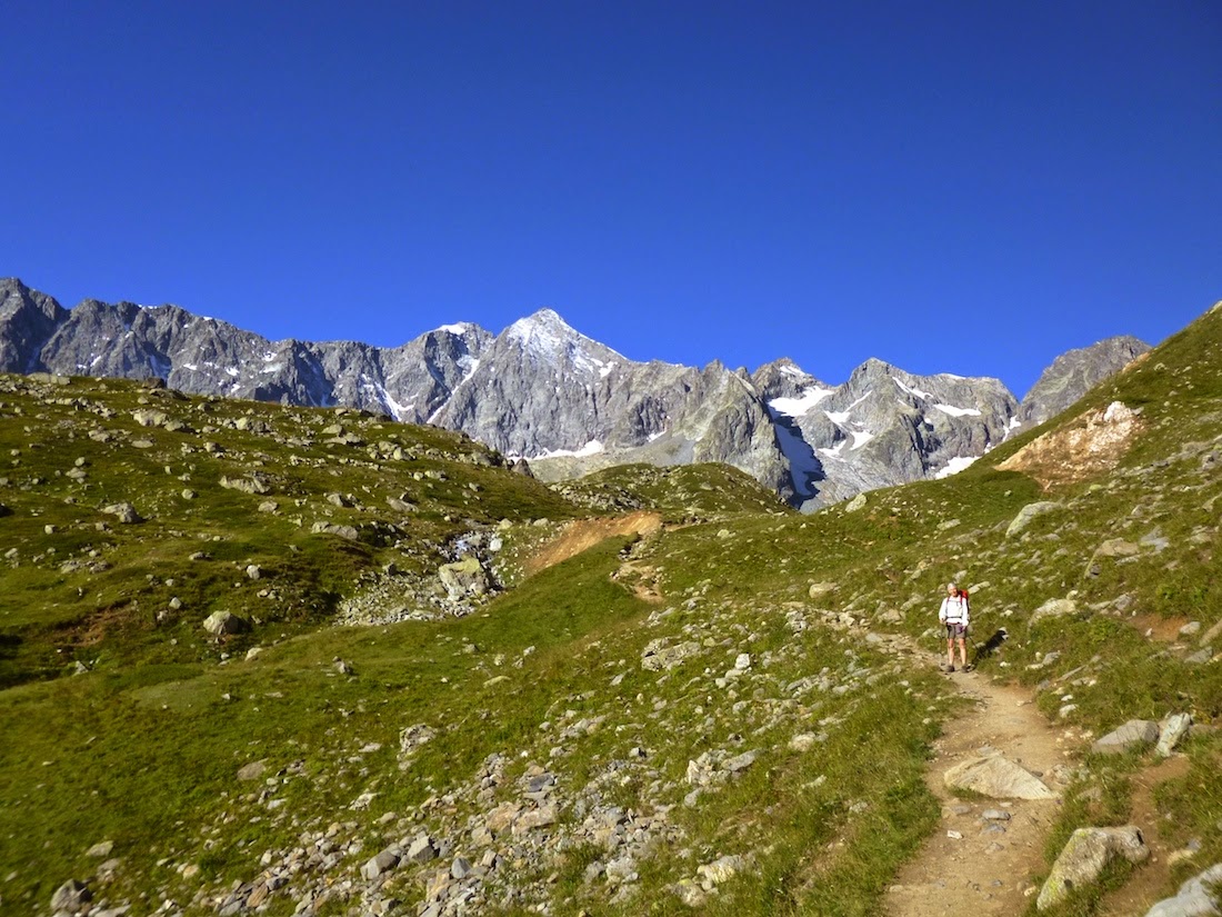
Okay, I'll be the first to admit it: we found today's 1700 metres of uphill walking to be a pretty hard slog and,by the time we were finished, wondered what we'd let ourselves in for. Our saving grace was the training we did at home on Kunanyi/Mt Wellington before leaving for France to walk the GR54.The initial part of today's route was steep but interesting and passed through a tiny hamlet near Huez high above Bourg.
A tiny hamlet above Bourg d'Oisans
Next, a lovely section of track traversed through forest ...
One of the delights of walking in the forest above Bourg d'Oisans
... before delivering us on the road from Huez up to our high point for the day at the Col de Sarenne. Not to put too fine a point on it, hiking up the road was rather tedious, especially with the number of cyclists riding past reminding us that there was a more efficient - yet still human-powered - way to travel on bitumen! A lunch stop for a great bowl of soup and home-made bread revived our spirits and we set off on a long descent before the steep climb to the charming village of Besse, a beautiful, old alpine village.
A glimpse of Besse
Made us think of Heidi a bit, actually (I know, wrong country, but still ...).
After a short descent on the road the rest of the day's walk was on trails. Shortly after leaving Besse we got a view across the narrow valley we were ascending to a gorgeous, isolated alpine hamlet ...
A tiny isolated hamlet clings to the side of a narrow valley
More climbing followed - up and up and up through a couple of minor passes to reach our high point for the day, Col de Souchet at 2365 metres. We enjoyed glorious walking through the Plateau d'Emparis, passing by a herd of sheep and goats ...
Free ranging livestock on the Plateau d'Emparis
We would have liked to linger in this area but a cool wind arrived, bringing drizzle while we were hiking across the higher parts of the plateau so we pushed on instead. As we neared Le Chazelet the weather picked up and we were rewarded with clear skies and wonderful panoramic views across to La Meije.
View towards La Meije from Plateau d'Emparis
Eventually we found ourselves at the top of the twisty descent down into Le Chazelet itself, which is a ski village in winter and popular centre for hiking in the summer. We were gobsmacked to suddenly come across streams of people, many of them family groups - some of them comprised of three generations, coming up the hill towards us. It was really wonderful to see the numbers of people out enjoying the environment. By the time we got down into Le Chazelet we were ready for a late lunch of crêpes salées followed by a lazy afternoon.
We woke today to a cold morning with a dusting of fresh snow on the higher peaks illuminated against a eggshell-blue sky. As we set off through the village, Di was a bit befuddled with water pouring off some of the roofs; where could it have come from, she wondered? With no gutters, the roofs were just releasing the frost as it melted. A short hike up the road leading into the sunshine warmed us up ...
Looking back at Le Chazelet
... which was followed by the descent to La Grave, a very touristy ski village and very different from either Besse or Le Chazelet. We did not linger: this was not what we'd come for! Back on the track, lovely walking up along the Rive Romanche led to Villar d'Arène, another gorgeous village high on a mountain slope. An amateur bike race was just setting off from the town square as we arrived. As we continued onward, we left the upper reaches of the Romanche ...
Leaving civilisation behind
... for a scenic path which led up into a high hanging valley where we found the Refuge l'Alpe de Villar d'Arène, which enjoys brilliant views of the peaks ringing the head of the valley. We felt very lucky that we'd had another clear day in the Alps ...
About where we had lunch on day 3
... when the weather had been pretty ordinary throughout the summer and not very promising when we'd arrived in Bourg a few days earlier.
This is probably starting to sound monotonous but, yet again, a frosty start led to yet another gorgeous day. The walking was sublime for most of the way. Initially, a relatively short, gradual, open climb with great views led up to the Col d'Arsine (2340 metres).
Looking around the Col d'Arsine
That was followed be a lovely descent ...
Di starting down the long descent into the valley
A little further down the valley
... along a stream to the attractive Lac de la Douche. It was a little early and cool for a swim so we kept on down through the forest to the small village of le Casset where we hoped we might get some refreshment. Nothing doing, so on we went to Le Monêtier-les-Bains (essentially a ski and spa resort town) where the attractions of the first patisserie we encountered were too much to resist. We arrived at the Gîte Le Fourou and, although a little non-plussed we weren't able to access our room and get a shower until 4:00 p.m., that inconvenience was more than made up for by having a room to ourselves and the fantastic evening meal, sharing a table with a bunch of convivial Belgians and a Frenchman named Philippe de Brion. As Philippe seemed like a jolly sort of fellow and was going our way, we asked if he'd like to join us in the morning.
Now a party of three, Philippe, Di and I set off early for the long climb up towards Col l'Echauda. The first two hours were spent in a lovely forest; like the section of forest on the first day, we found lots of flowers along this part of the trail ...
More forest flowers
... and then some lovely open walking along what are ski slopes in winter followed ...
Looking back the way we'd come
... passing some patches of beautiful wildflowers ...
Another beautiful mountain trail
We spent some time walking up a gravel road through a ski area. Not the nicest part of the route so far. After crossing a new high point of 2425 metres for our route, we found more beautiful grassy slopes and soon stopped for lunch, with fine views looking down into the valley below. There was also this unusual plant growing at that spot ...
Lunchtime oddity
Soon the trail descended very steeply before easing off just above Chambron, a popular spot for day-trippers to set off on various excursions. Here we joined the road which we more or less followed - with intermittent detours - down to Vallouise. As with most GR routes, there seems to be lots of water points in small settlements along the way. Here's one we came across a half hour or so before arriving at Vallouise ...
One of the more stylish waterpoints we've encountered
We were able to access Le Baoüti, the gîte we'd pre-booked, as soon as we arrived (well, after stopping for a beer first!) and Natalie, our charming hostess was also able to provide a single room for Phillipe. Di and I had a room to ourselves with our own shower and toilet - merveilleux! The day was topped off beautifully when our long-lost friend Carol Nash - whom we hadn't seen for at least 25 years - and her daughter Jess turned up to have dinner with us. yet another fantastic, footloose and fancy-free day!
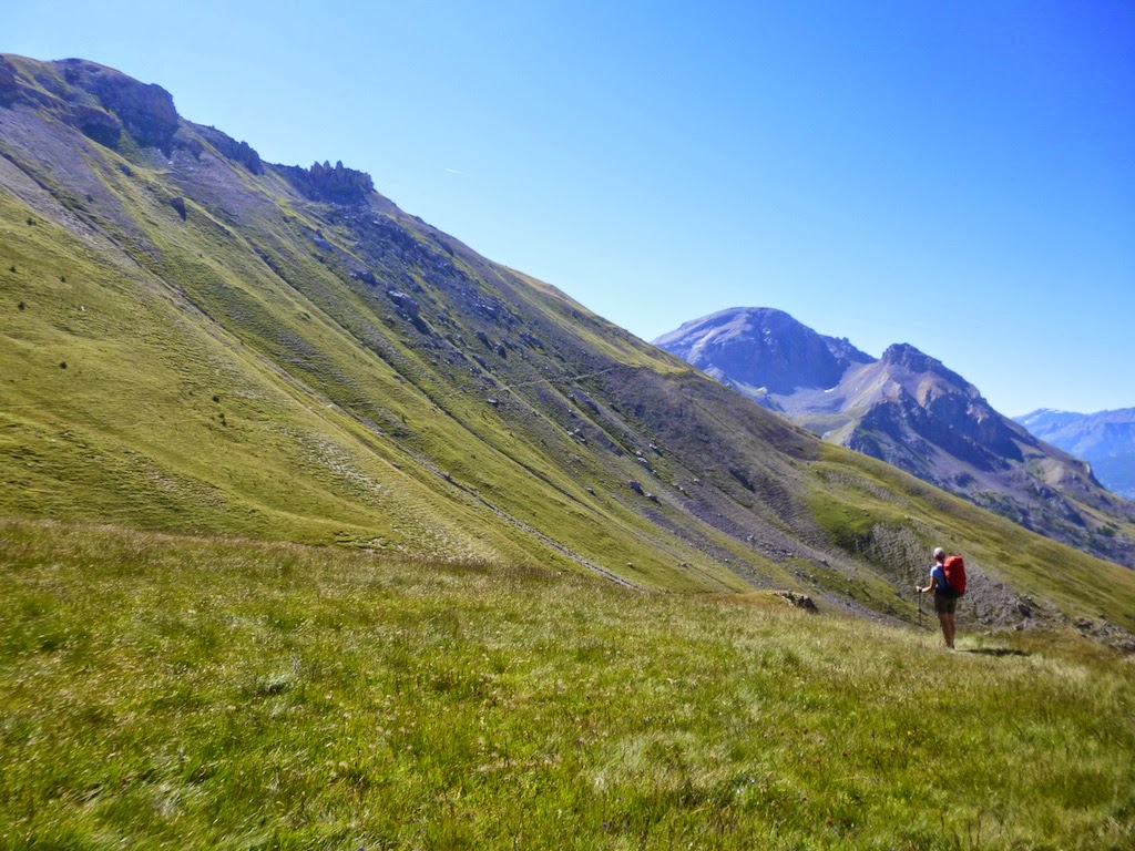
We'd been persuaded that it was a good idea to take the bus up to the end of the road at Entre-les-Aygues, saving us about nine kilometres of walking on bitumen and about 400 metres of ascent.
A new variation on foxgloves for us: yellow rather than mauve
With the 1160 metres of climbing that we did have - in and out of light showers - this certainly was a good move and one we'd recommend.
All the tired horses in the sun ... how'm I supposed to get any ridin' done?
Mountain hut using features of the landscape
An interesting rising traverse across the schist-comprised cirque at the head of the valley brought us to the Col de l'Aup Martin which, at 2761 metres, is the high point of the GR54.
Philippe nearing col de l'Aup Martin; Dianne a little way back
It was cold and windy up at the top so we continued onward in search of a warmer and more sheltered spot for lunch. After contouring around to Pas de la Cavale ...
Traversing towards lunch!
...we dropped down far enough to find a spot out of the wind for a welcome rest and lunch, about 4 hours after setting off. The descent to the refuge was very steep, dropping nearly 1000 metres in quite a short distance. The refuge itself is a beautiful building constructed in 1980.
Refuge du Pré de la Chaumette
Remarkably, although there were lots of people up for lunch there were only 6 of us in the refuge for dinner, so it was quite a pleasant, intimate evening. Even better was the situation with the dortoirs: the guardian of the refuge was happy to give Di, Philippe and me a room to ourselves and put the other guests in a room of their own. (It seems to be more common to have everyone packed in together in this situation to save on cleaning.)
Wow! What a day! We crossed three high cols before a long, long, long descent. The first col was our high point for the day ...
Looking ahead from the top of the first col
... it was followed by a short descent ...
Descending the schist just under the first col
... into a lovely hanging valley where a group was just packing up their camp after spending the night. We had a pause at the top of the next col for a snack and to look at the route ahead ...
The route ahead lies over the corrugated ridge right of centre
A longer and more arduous descent and ascent took us to the top of Col Valonpierre ...
Di on top of Col Valonpierre
From there we could look back through the second col to our high point for the day and ahead to the Refuge de Vallonpierre, which is situated in a gorgeous spot by a tarn which we chose as our lunch stop. We noticed some interesting clouds building as we continued down valley ...
Threatening clouds build above
The very long descent to our destination for the night was highlighted by a stop to eat some wild raspberries that Philippe found growing beside the track ...
Framboises found by Philippe
This day, our longest of the tour, ended just as the rain - and it was VERY heavy - arrived.
Si hier était le jour des framboises, aujourd'hui c'est le jour des myrtilles. (If yesterday was raspberry day, today is blueberry day.) We started - uncharacteristically - with a pleasant, slightly downhill stroll for an hour to the village of Villar-Loubière.
An old mill in Villar-Loubière
And that's when things changed. We climbed 1000 metres to the lovely Refuge des Souffles where we paused for some morning tea. When we set off again to climb the remaining 500 metres to the Col de la Vaurze we discovered myrtilles in abundance just near the refuge and naturally paused for a little grazing. After a long northwest and then southwest traverse the route finally climbed very steeply to the col where we paused for a long, long lunch break.
Another trackside attraction
These rock formations grabbed our attention on the way up the hill
A false summit
Cette marmotte regarde moi avec suspicion!
Looking down into Désert-en-Valjouffrey
Eventually feeling refreshed enough to continue, we found an initial steep descent on now-familiar hard-packed schist took us to a long traverse and another steep descent towards le Désert-en-Val-Jouffrey, a tiny town with a brilliant gîte d'etâpe.
Another view from the col
Like many of the descents on this Tour des Écrins, when observed from below this one looks so improbable; given that the route drops 1250 metres over a distance of 4.6 kilometres with a long traverse in the middle, it's not surprising our guidebook describes it as "knee-wrecking".
That's our col in the distance, slightly right of centre
As we arrived in the village we were treated to an age-old tradition: bringing the cows in from the hills for milking ...
As per usual the day started pretty much straight uphill. At least the climb was more moderate than yesterday's at just over 1000 metres and on a good surface. We reached the charmingly named Col de Côte Belle 2 ¾ hours after setting out from the refuge and had a break for a snack and to enjoy the panoramic views, both back the way we'd come and the route ahead.
Looking down at the winding track leading up to the Col de Côte Belle
Three amigos atop Col de Côte Belle
Overlooking Val Senestre
Our guidebook had highlighted the descent with descriptions of sections that featured "spiky, shattered, slate-like slabs" and "a wild alpine garden".
Rock coming apart at the seams!
Any moment now ...
Part of the "wild alpine garden"
Further down we traveled through stands of young birches and larches, suggesting that an avalanche had swept through this section of the track in the not-too-distant past. Throughout the descent we were confronted with the intimidating climb of the Col de la Muzelle, one of the highest on the GR54 and where our journey will take us tomorrow. Many times we stopped, awe-stricken, looking across at the improbable route.
The view across to the Col de la Muzelle with its intimidating upper section
Upon our arrival in yet another tiny alpine village we were delighted to meet our hostess Helène at Le Bélanger, another gîte d'étape and the only accommodation if one wants to stop hereabouts. Not only was Helène a delightful hostess, she was a wonderful cook: our meal here was probably the best we had en route. As I sit writing this and sharing a bottle of Vinsobres with Di and Philippe I can smell dinner cooking and it is driving me crazy. This gîte has the reputation of having the best food on the GR and my nose is telling me why. Bon appetite!
Like most of the cols we've had to climb here in the Alps, the Col de la Muzelle was a lot easier than it looked. The 1300 metres of ascent from the village of Valsenestre took us 2 hours and 43 minutes with Di setting a sure and steady pace the whole way.
Looking back towards yesterday's pass
We were on the fearsome-looking section of schist at the top before we knew it and were delighted to discover an excellent wide path had been worn into the surface, making it the easiest part of the ascent. This little creeper with its beautiful flowers grew straight out of the schist ...
Clinging to life
Unfortunately, the overnight rain left the skies mist-laden for the entire ascent so we were only able to get brief glimpses of the surrounding peaks and the Col de Côte Belle, which we crossed yesterday. With no clear indication (pun intended) that blue skies were imminent we decided not to linger at the col.
Philippe leaving Col de la Muzelle behind
Di heading towards Refuge la Muzelle
The short descent to the refuge only took about an hour, making for a very short day indeed. We've had an early lunch and are looking forward to a relaxing afternoon enjoying the magnificent views from the refuge's sunny, south-facing terrace overlooking the beautiful Lac Muzelle.
Looking back towards Col de la Muzelle from the refuge
Day 11 Refuge de la Muzelle - Bourg d'Oisans
Holy Moly! We have finished the Tour des Écrins! We can hardly believe it. On paper this looked like an easy day, although the descent of 1850 metres to our final destinationposed a question for our knees. It was quite a cool morning. Di - being Di - was well rugged up.
Leaving Lac Muzelle
Looking back at Lake Muzelle on the approach to Col du Vallon
As we'd spent the night over 2100 metres, the 400 metre climb up to the Col du Vallon was pretty easy, then it was all downhill from there.
Col du Vallon ~ our last col on the GR54!
Looking down towards Lac Lauvitel
The route descended steeply - hmm, there seems to be a bit of repeating theme here - to Lac Lauvitel and then continued in the same manner right down to the floor of the valley of the Rive Romanche. The highlight of the day was definitely the views we enjoyed on the descent to Lac Lauvitel. By the time we'd arrived at the lake we realised why the route down was so convoluted: steep walls circle three sides of the lake making for a spectacular setting.
At Lac Lauvitel
Further on the path was paved for a very long distance and, it being Sunday, lots of people were making their way up into the mountains. It was a joy to see so may folks out enjoying their local environment. Actually, I think my real highlight for the day was my brief chat with two petits randonneurs who were about four and five years old: they were very excited about the prospect of seeing some marmots. This left me with a grin that lasted right through the seemingly endless lower section of the walk before arriving at Bourg d'Oisans and our finishing point. I experienced one last treat of nature before we arrived in Bourg ...
Butterfly on Lilac blossom
... and finally we were there!
We arrive at the Office de Tourism in Bourg d'Oisans
Le Tour des Écrins In Summary
A glimpse of Le Tour des Écrins from a Google point of view
There was no doubt we were lucky with the weather. Our heightened sense of enjoyment would have been tempered considerably had it been colder and/or wetter at various points along the route, especially climbing the slopes up the the col de l'Aup Martin, as well as descending the slopes immediately below the Col de Vallonpierre and Col de la Muzelle which were all on steep schist and would have been quite slippery when wet. We were rapt with our packs and their contents: they were the lightest we've carried on a multi-day hike and will be the template for any future excursions of this sort. For both of us, a couple items of warmer clothing didn't get much use but that would have been different had we experienced bad weather. The valleys generally are steep and narrow; the scenery magnificent and the hospitality in refuges and gîtes excellent. Interestingly, two of the gîtes were owned by the local commune, as was one of the refuges. A very smart way to support tourism in those more remote valleys, and apparently very successful. We walked 167 kilometres, crossed 14 passes and ascended - and of course descended - 12,830 metres over 11 days. Maybe the best indicator of how we found the GR54 was that when I asked Di and Philippe which day was the best, we all simultaneously said, "The longest day!" The combination of the three passes close together, a fantastic lunch spot, eating raspberries, a long and varied descent and beating the rain into town meant a lot was packed into that day. The only slightly disappointing thing about the hike was that we saw little wildlife: apart from lots of marmots there were only a few birds. Would we do it again? In a heartbeat - if there weren't so many other things on the bucket list!