A Walk in the Mountains?
We are now back home in Tasmania after an extended cycling and hiking trip in Europe. Finally I feel like I am getting enough on top of things to have a look back at our traverse of the Alps, from St Gingolph on Lake Geneva/Lac Leman to Menton on the Mediterranean Sea.
Warning: this is a bit of an epic read for a blog
so you might only want to look at the pictures.
However, if you like a good yarn, settle in with
a cuppa and I'll tell you about our month of
hiking from St Gingolph to Menton.
 |
| Into the mountains |
Since retiring in 2010 and traversing the Pyrenees, my wife and I have become rather addicted to doing long hikes in Europe. We started out carrying camping gear but in the interim, thanks to ageing joints, we've transitioned to hiking hut-to-hut, with the odd gîte d'étape and cheap hotel thrown in, depending on what's available in any given location. We love being in the mountains and, besides the traverse of the Pyrenees, have hiked in Corsica and in the Ecrins massif of the southern Alps.
Di had been looking at the grand traverse of the French Alps since before we quit working: it was the other option alongside the Pyrenean Traverse that she most wanted to do and we finally decided to get on with it this year before we felt it was beyond us.
Here is a rather rough view of the the route, courtesy of Google Maps ...
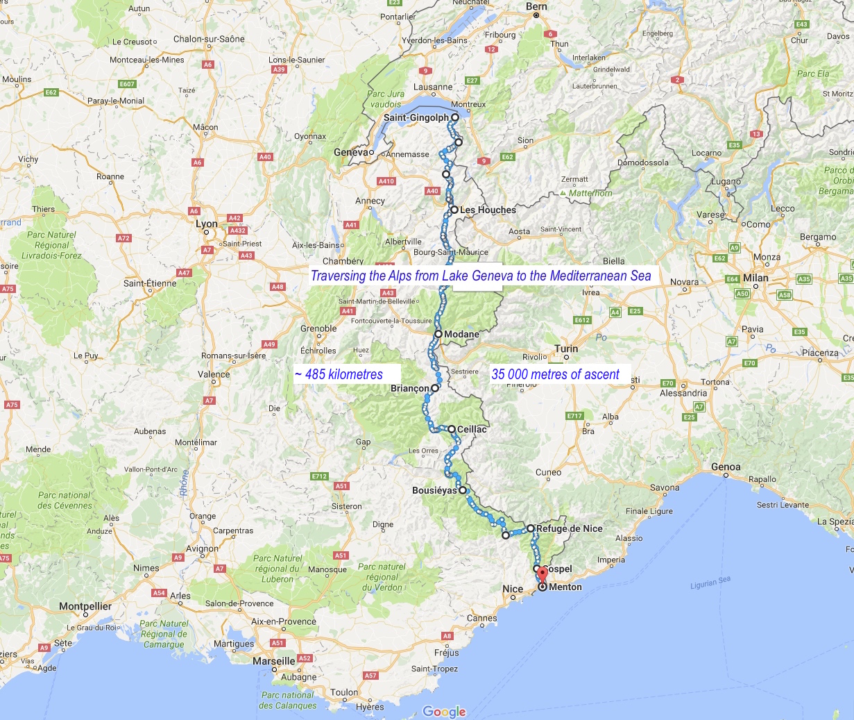 |
| Our route through the Alps |
... and another map showing the hike in an overall context of western Europe ...
 |
| Alpine traverse in the context of western Europe |
Di is generally the logistics manager for our European hikes and, using the Cicerone Press guide to the GR5, put together combinations of the GR 5, 55 and 52 in order to take in the most spectacular aspects of the journey south. Wherever there was a choice she elected for a high rather than a low route.
In Your Face From the Get-Go!
Having decided to start at St Gingolph rather that Thonon-Les-Bains in order to save a day, we knew we were in for a tough start. Here's a graphic from Google Earth showing the route to Chapelle d'Abondance ...
 |
| St Gingolph to Chapelle d'Abondance |
Although we only had 18 kms of ground to cover, there was 1880 metres of elevation gain, the second greatest for the whole trip. It was a bit confronting and we were very pleased that we arrived in a town and had accommodation in a hotel for the night.
Reacquainting ourselves with mountain hiking
We were pleased that our next day, although a little longer, had 400 metres less elevation gain.
This meant of course that overall, the gradients would also be a little less steep on average. The route took us into Switzerland for our only night outside France, and it was at the intimate Refuge de Chésery ...
 |
| Refuge de Chésery |
There are two great things about staying in these alpine refuges: first, they are good value - one always gets plenty to eat at the dinner table; second, there are opportunities to meet and converse at leisure with other hikers - particularly if prepared to make a bit of an effort to speak a few words of French. We got friendly with François and Nicole (the couple sitting opposite one another dressed in red) and hiked on and off with them for several days before they left the route.
I had to stop and take a photo of this sculpture, as it reminded me of the way logs were moved along the rivers in Eastern Canada back in the pioneering days ...
 |
| "Le flottage du bois" |
There was a bit of rain off and on in the first few days of our traverse, particularly on the fourth day when we hiked from the hameau of Le Salvagny. The next photo is of the two of us standing in front of the Cascade du Rouget, and was taken by a cyclist out with a group who were about to retreat to the warmth and comfort of their hotel to watch the Tour de France.
 |
| Cascade du Rouget |
We didn't have that luxury and pressed on through mist and rain past the Chalets d'Anterne ...
 |
| Chalets d'Anterne |
... then over the Col d'Anterne to the Refuge de Möed d'Anterne. It was here that we faced our first disappointment: word was that our route over the spectacular Col de Brévent had received a lot of recent snow and was not suitable for hikers. Staff at the refuge were advising strongly against going this way to Les Houches and the valley of Chamonix, our destination for the night. Reluctantly, we changed our plans and headed down a long valley to Servoz. At least we had excellent views of the Mt Blanc massif almost all day. Here is one view early on the descent ...
 |
| Mt Blanc from near Refuge Möed d'Anterne |
On into the Parc National de la Vanoise
After a day's rest and doing the tourist thing in Chamonix we met up with our friends Philippe and Veronique and their friend Philippe and set off into perhaps the most beautiful part of the French Alps. The plan was for them to walk with us through to Briançon for the next twelve days. Here are Veronique and Philippe tightening their laces outside the Gîte Michel Fagot (made marvellous by the wonderful Ameline) in readiness for the steep climb out of Les Houches ...
 |
| Philippe and Veronique in front of the wonderful Gîte Michel Fagot |
The only downside to this part of the hike was that the GR5 and the extremely popular Tour du Mont Blanc share the same route for a day and a half, meaning that there were more people on the track than we shy Tasmanians are used to seeing! Di took this photo at the Col de Tricot ...
 |
| Philippe #2 in from of the crowd at the Col de Tricot |
The upside to the day was that our friend Michel had joined our party in Les Contamines, and there was some great bonding between the four Frenchies over a few glasses of wine. Michel was going to walk with us for six days through the Vanoise where he'd not been hiking, before having to go back to work in Toulouse.
Aside: on the way to the refuge in Les Contamines we were surprised to find a little reminder of Tasmania ...
 |
| A hint of Tasmania in the heart of the European Alps |
Day 7 was one of the loveliest days hiking I can remember, despite the crowds during the morning. We crossed the Cold du Bonhomme, where we enjoyed marvellous views, an excellent lunch and the company of a flock of sheep - some of whom got up close and personal ...
 |
| G'day mate! |
... and then it was across to the Refuge de la Croix du Bonhomme - where we split off from the Tour du Mont Blanc and on to have a bite to eat at the start of the wonderful Crête des Gittes ...
 |
| Michel has the munchies |
The crête stretches for quite a distance, and affords fantastic walking with wonderful views either side ...
 |
| Early on the Crête des Gittes |
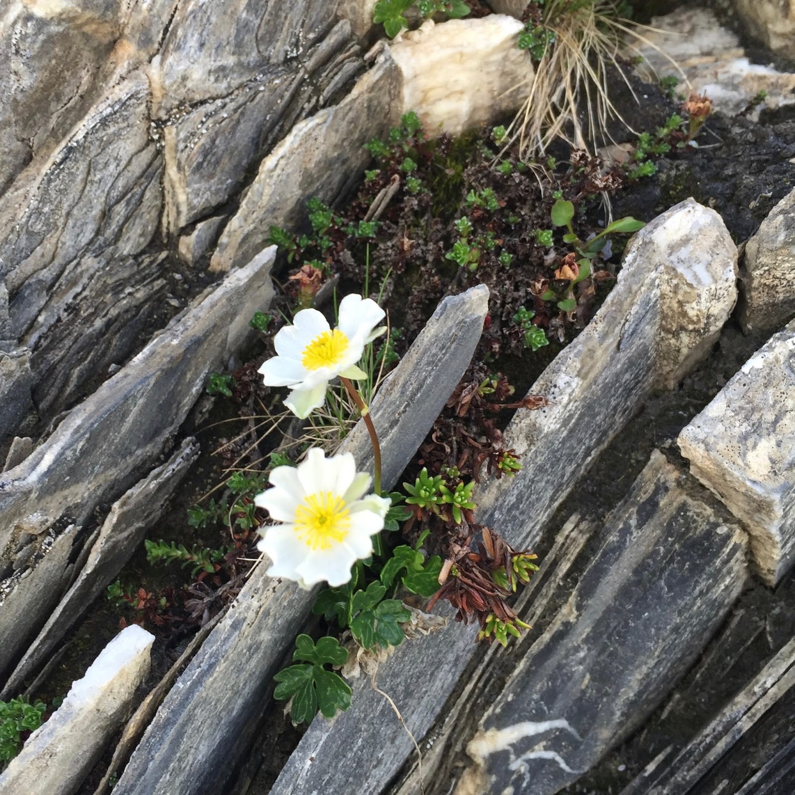 |
| Flowers and schist along the Crête des Gittes |
 |
| Still two bumps to go! |
The next day was another tough walk, with lots of up and down. There were more fantastic views ...
 |
| Flowers, alpage and snowy peaks |
... Philippe and Veronique decided the pace that Di had set for us was a bit too torrid for them to really have an enjoyable, relaxed escape from work, and adjusted their schedule to move a little more slowly. We were sorry to see them leave but understood that they were unwinding and gathering strength, whereas we'd already had the benefit of a month on our bikes to get fit. Their friend Philippe continued with us through half of the next day ...
 |
| Philippe on the march |
... before he too decided to ease up his pace. Hopefully we will be able to spend time in the mountains with Vero and the two Philippes at a more moderate pace the next time we are in France!
We had a few more days with Michel to enjoy the delights of the flowers ...

... the cosy company of families and other folks at Refuge d'Entre-Le-Lac ...
 |
| Refuge d'Entre-Le-Lac |
... more flowers ...

... a stop at the fantastic Refuge du Col du Palet ...
 |
| At Refuge du Palet |
... before descending to the ski village of Val Claret, over another col and on to the Refuge de la Leisse.
The next day was another stunner, taking us down a beautiful valley ...
 |
| Alongside the Torrent de la Leisse |
... up over a col, through a gorgeous hanging valley replete with marmots to the Refuge du Col de la Vanoise, through Lac des Vaches ...

... and on to Refuge les Barmettes for our last night with Michel, who we farewelled in the town of Pralognan.
Re-equipping and continuing southward, ever southward
By the time we got to Pralognan my shoes were in a sorry state. Although good for most of the tracks we were hiking at home they just weren't robust enough for the snow and rock we had been encountering over the past couple of weeks. Luckily I found a good pair of Millet hiking shoes ...
 |
| New, blue (suede) shoes ... |
... that fit my misshapen feet well. (And yes, they are made out of blue suede, but also lined with Gore-Tex.)
After having a coffee with Michel in Pralongan we left him to catch a bus and walked up the valley with some urgency because the forecast was for an afternoon thunderstorm. Arriving at Refuge du Péclet-Polset ...
 |
| Refuge de Péclet-Poset |
.. just before the front hit with a big bang, instantly filling the skies with water and transforming the landscape into a streaming sea. The storm arrived a couple of hours earlier than normal, which didn't augur well for the next day. With the forecast for an even earlier storm, we resolved to leave early in the morning in an effort to get over the 2796 metre Col de Chavière - the highest col on the whole traverse - before the skies opened.
We made good time to the col, although I had to stop a few times along the way to take the occasional photo. My attention was arrested by some flowers on a hillock ...
 |
| Approaching Col de Chavière |
As you can see, there is still plenty of snow about ...
 |
| Closing in on the Col de Chavière |
... and here's Di arriving at the col ...
 |
| Finally: the Col de Chavière |
We didn't linger, as the weather was looking more and more threatening. Down the other side we went, where the skies seemed to be lightening ...
 |
| Is the weather lifting? |
Disappointingly - but not unexpectedly - the clouds moved back in almost immediately, and light rain began to fall. However, a little way further down the valley our mood transcended the weather when we came upon a herd of bouquetin - all males - and managed to get a few photos despite the poor light. Here's one of the better ones ...
 |
| Bouquetin grazing |
Shortly after the skies really opened and we donned our rain jackets. Here's a photo of Di, taken just as we were leaving the boundary of the Vanoise National Park, with water streaming down the hillside behind her ...
 |
| Leaving the Vanoise in the rain |
It was another couple of hours downhill to the town of Modane straddling a major road and railway line just near the border with Italy. The town was shrouded in fog by the time we arrived, and had a pretty dismal feel to it.
Our mood was not helped by the forecast: snow down the the 2000 metre level and strong winds. Given that the plan for the next two days into Briançon involved long hours of hiking with lots of time spent above 2000 metres we reluctantly made the decision to pull the plug on that section of the hike. Instead we bussed into Bardoneccia in Italy for a day's R&R and sightseeing ...


The next day was a transit day via train to the charming, historic town of Oulx, where we had a couple of hours to wander around, taking in the sights ...


... and then it was the bus to Briançon, where we had a previously scheduled rest day. While we were disappointed not to be able to do the two days by foot from Modane, the truth is that we were pretty tired from the ten days straight of hiking that we'd done between Les Houches and Modane. An extra couple of days of rest did us the world of good, and it was nice to dip into Italy unexpectedly.
Exploring the Queyras
Most people who know a bit about the Alps are familiar with the northern half, less so with the terrain further south. As mentioned previously, we'd done some hiking in the Écrins National Park, hiking the gorgeous circuit of the GR54, also known as the Tour de l'Oisans. We had also spent a month further east climbing in the area around Briançon and were looking forward to hiking through the Queyras region.
Although generally drier than the topography further north, there are still plenty of high passes with lots of snow on them. As we expected the Queyras proved to be very beautiful. In fact, perhaps the most beautiful lake we walked past on the whole traverse was Lac St Anne near the Col Girardin ...
 |
| Lac Ste Anne (2415 metres above sea level) |
Although perhaps too small for it to have been considered for National Park status, the Queyras Park Naturel is quite varied for its size. We walked through high dry valleys ...

... crossed rubbly peaks ...

... and walked past a number of ruined forts guarding high passes ...
 |
| Baraquements de Viraysse |
We saw more marmots ...

... and beautiful lakes high in the mountains ...

We navigated what seemed like a whole world of rock up a high valley ...


... before we crossed yet another col and descended a massive scree slope ...

... and then found ourselves surrounded by a mob of sheep feeding in a high pasture ...

Almost before we knew it we were through the magic of the Queyras and ...
On to the GR52 and the Mercantour National Park
The jumping off point for the Mercantour is the medieval village of Saint Dalmas in Valdeblore. We arrived here early in the afternoon to find the gîte we'd booked wouldn't let us in until 4:00 p.m. Considering that we had a rest day scheduled for the next day, we wouldn't be allowed in the gîte between 10 and 4, and thunderstorms were forecast, we were none too pleased and went looking elsewhere. Happily we found a charming family-run hotel called the Auberge des Murès. (Highly recommended if you're passing through this part of the world.) After a lovely rest exploring the village we felt ready to tackle the rugged Mercantour.
Paradoxically, and somewhat irksomely, to make the most of the traverse south through the fabulous Mercantour one must walk north for half a day from St Dalmas to get into the heart of the park. But hey, once you're on the way, you're on the way, right?
This part of the GR starts relatively innocuously, with a long but gradual climb up through forest which eventually gives way to open slopes of grass ...

... but then the landscape changes quite dramatically, and one is immersed in a world of gneiss, with fantastic rock architecture everywhere and some quite rugged hiking amongst it all. Here's a sequence of three images to give a hint of what I'm talking about ...


Amongst the wild landscape we were delighted to get up close and personal with a chamois ...

Every once in a while a fabulous lake will reveal itself ...

These are days to be savoured. Just look at this for a landscape ...

After all this ruggedness, wonderful as it was, we found it very pleasant to finally traverse via a relatively smooth section of path beside a small lake ...

... into the Vallée des Merveilles, a famous pre-historic site strewn with ancient petroglyphs.
And, after this there were only two more days of hiking to Menton. The first of those was a bit of a killer though: 31 kilometres, with 1000 metres of ascent and 2600 metres of descent landing us in the old town of Sospel, which was an important staging post on the ancient salt route running into northern Europe from the Mediterranean.
One thing you can say about the route to Menton is that it is full value: even on the last day when you are so close to the end, there are still three cols to cross before the descent to the sea. Here is a photo of us - looking a bit weary and sunstruck - at the very last of those, the Col de Berceau ...

... and then finally, about halfway down the last incline, after the morning sea fog had cleared, we were able to see Menton on the Mediterranean Sea ...

And that's our story. If you're a glutton for punishment, you can see more photos here. We used the Cicerone Guide to the GR5 to plan our trip, and used the digital version when we were on the route. There were a number of errors that were irksome at times, but a new edition is out that apparently addresses some of those mistakes. Along the way we actually picked up the last three of the French topo guides for the route because we liked the layout and size, and found them very useful and informative about the natural history. Di also used the French iPhiGénie maps App for her phone so we had the equivalent of a GPS along the way, which was very useful in general, but particularly a couple of times on high cols when we were socked in with fog. The only thing we'd probably do differently is factor in a few more rest days so we wouldn't be so knackered, but it worked out that way anyway with our detour into Italy for a couple of days.
No comments:
Post a Comment
It's always good to hear from folks who have visited.
Please leave a comment!